
Research · Background
Historical background
How a Carolingian inheritance became a duchy, and how that duchy divided into the two Lotharingias — the southern of which is the territory whose dukes struck the coins catalogued here.
Arms and origin legend
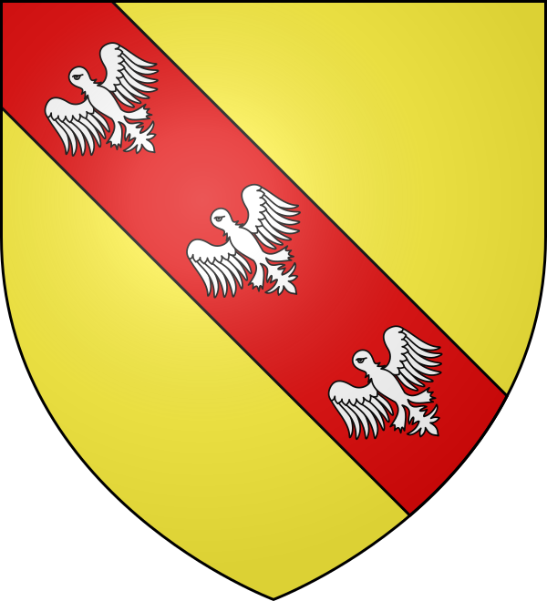
The duchy's arms show a golden field crossed by a red bend charged with three silver alerions — heraldic eagles depicted without beaks or claws. According to legend, during the Siege of Jerusalem in the First Crusade (1099), Godfrey of Bouillon, Duke of Lower Lorraine, caught sight of three eaglets on the Tower of David and brought them down with a single cast of his spear; he is said to have adopted the arms to commemorate the feat. They remain in use as the arms of Lorraine to this day.
Origins: from Lothair to Lotharingia
Source: Wikimedia Commons.
.png)
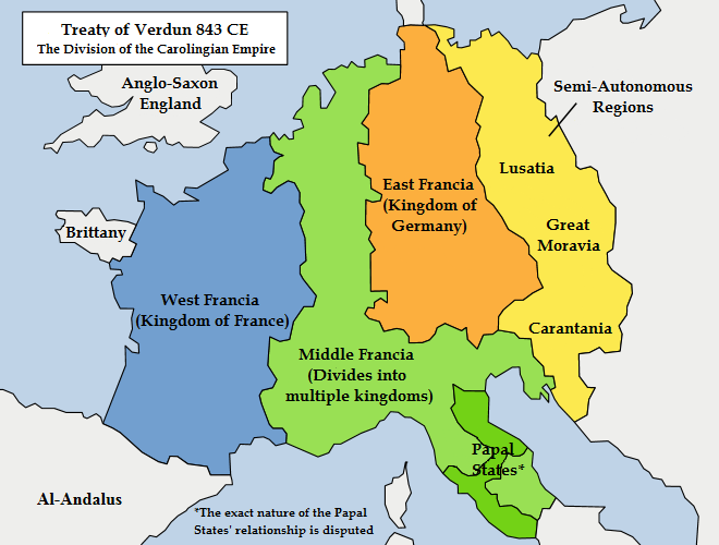
The history of Lotharingia began with the disintegration of the Carolingian Empire. Following the death of Louis the Pious in 840, a civil war erupted among his three sons, culminating in the Treaty of Verdun (843), which divided Charlemagne's empire into three parts. The middle son, Lothair I, retained the imperial title but received a rather peculiar territory: a long, narrow "corridor" stretching from the North Sea — through the Low Countries, the Rhineland, and Burgundy — all the way to Italy. These lands connected his two centres of power (Aachen in the north and Rome in the south); however, as a unified political entity, this territory was virtually ungovernable.
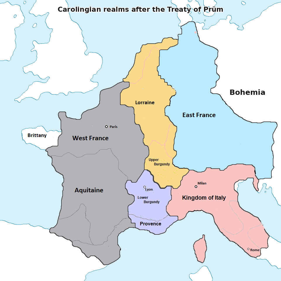
Lothair I died in 855, and his domains were immediately divided among his sons under the Treaty of Prüm. The northern third — essentially a corridor between the Rhine and the Scheldt, extending from the North Sea to the Vosges Mountains — went to his second son, who also bore the name Lothair (Lothair II). This kingdom was named Regnum Lotharii ("Lothair's Kingdom"); Latin-writing chroniclers Latinised this to Lotharingia. After undergoing phonetic changes in Old French, the word eventually evolved into the modern name: Lorraine.
From kingdom to duchy
The reign of Lothair II (855–869) was overshadowed by his attempts to divorce Queen Teutberga in order to make his illegitimate son, Hugh, his heir. All his efforts proved unsuccessful, and Lothair ultimately died without leaving a legitimate heir. His two royal uncles — Charles the Bald (ruler of the West Frankish Kingdom) and Louis the German (ruler of the East Frankish Kingdom) — immediately divided Lotharingia between themselves under the Treaty of Meerssen (870), drawing the border roughly along the Meuse River. A decade later, under the Treaty of Ribemont (880), the border was shifted westward, and virtually all of Lotharingia passed to the East Frankish Kingdom, becoming firmly integrated into the lands that would later form the Holy Roman Empire.
Thereafter, Lotharingia ceased to be a kingdom and became a duchy within the eastern realm — the Holy Roman Empire.
The partition of 959: Upper and Lower Lotharingia
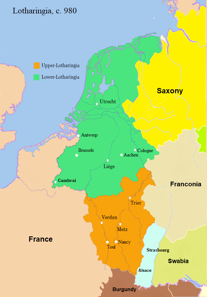
The Duchy of Lotharingia was too large to govern from a single centre; dukes had to travel constantly between the Frisian coast and the Vosges Mountains, while local counts managed their own affairs. In 953, to restore order, Bruno the Great — Archbishop of Cologne and brother of Emperor Otto I — was appointed Duke of Lotharingia. In 959, he officially divided the duchy into two parts, appointing deputy dukes (known as Unterherzöge) to govern each:
- Lower Lotharingia (Niederlothringen): the northern section, centred on the lower reaches of the Meuse and Scheldt rivers and the Rhine delta. This region included Brussels, Antwerp, Liège, Aachen, and Cologne. It was the precursor to the future Netherlands.
- Upper Lotharingia (Oberlothringen): the southern section, centred on the upper Moselle valley. This region included Nancy, Metz, Toul, and Verdun — the very territory we call Lorraine today.
The fates of these two parts differed significantly. Lower Lorraine fragmented rapidly; by 1100, it had effectively split into the Duchies of Brabant and Limburg, the Prince-Bishopric of Liège, the County of Hainaut, and other territories. The title of Duke there became purely nominal and soon vanished altogether. Upper Lorraine, however, consolidated, and by the mid-11th century, it came to be known simply as Lorraine (Lotharingia). The ducal dynasty that produced the rulers whose names appear on our coins — such as Ferry III, Thibaut II, René, and Leopold — originated in this Duchy of Upper Lorraine. By that time, it had become a sovereign state balancing between France and the Empire, until France finally absorbed it in the mid-18th century.